| Slovakia Genealogy Research Strategies | ||||||
| Home | Strategy | Place Names | Churches | Census | History | Culture |
| TOOLBOX | Contents | Settlements | Maps | FHL Resources | Military | Correspondence |
| Library | Search | Dukla Pass | ||||
Michael Habler, September 2005
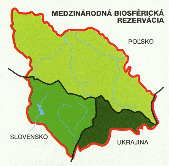
Hiking the Kremenec Stužica Virgin Forest Eastern Carpathian Biosphere Reserve
"Kremenec" is a point on the Carpathian Mountain ridgeline where three nations touch: Slovakia, Poland and Ukraine. The only way to reach this peak is on foot. It is a moderately difficult hike, being in good shape is clearly a requisite. The land is remote and heavily forested, rare vegetation forms are found, virgin forest tracts exist along with wolves and Ural owls. Following the mountain ridgeline is a popular sport among Polish youth.
"HERE, it's the foxes that tell people good night," laugh the inhabitants of the easternmost Slovak village of Nová Sedlica. (Slovak Spectator, 2003)
|
Thanks to Michael Habler of Germany for sharing his
hike to the easternmost
peak in Slovakia, the Kremenec. Michael began his journey in Nova Sedlica.
The following text was originally rendered in German and edited with a focus on East Slovakia. |
 |
“Now it became time to return to … Medzilaborce and turn left on a small road … towards the destination "SNINA". This leads to a picturesque and (seemingly) unaffected landscape, where there are nearly no cars to pass or meet. In each village one sees stork nests on old chimneys, a typical scene for this landscape. In these villages one is assumed to be a tourist, the people often curiously look at the "stranger".
 The people are obviously surprised, what do they want in this small village?
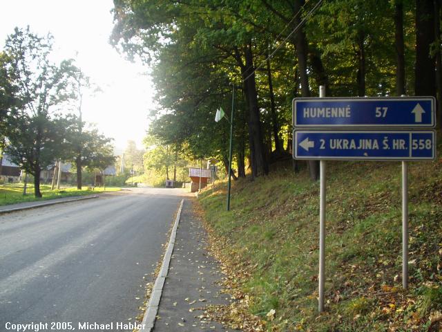
After passing more small settlements, I pass through SNINA and then Stakcin.
There the road divides, left continues to go "to the end of the world" (more on
this later) and right to Ubľa toward the Ukrainian border. A small force lures
me closer to the border, however it was becoming darker, it was time to get to
my pension, where they surely already waited for me. Thus I turned in the
direction of Ulic on the left and arrived after short stop at a picturesque
drinking water reservoir Starina, which was created in 1987.
The people are obviously surprised, what do they want in this small village?
After passing more small settlements, I pass through SNINA and then Stakcin.
There the road divides, left continues to go "to the end of the world" (more on
this later) and right to Ubľa toward the Ukrainian border. A small force lures
me closer to the border, however it was becoming darker, it was time to get to
my pension, where they surely already waited for me. Thus I turned in the
direction of Ulic on the left and arrived after short stop at a picturesque
drinking water reservoir Starina, which was created in 1987.
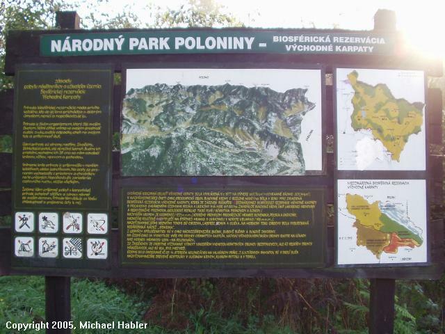
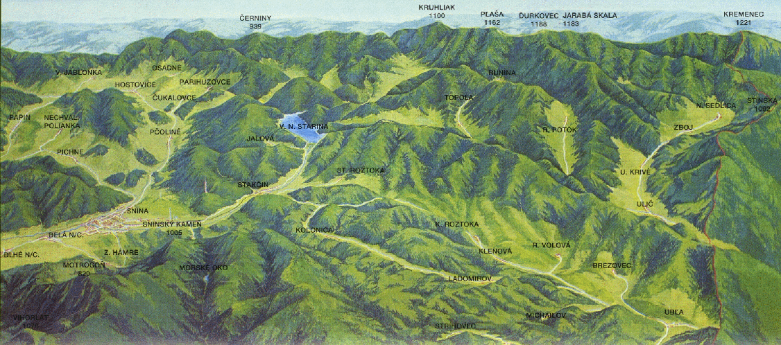
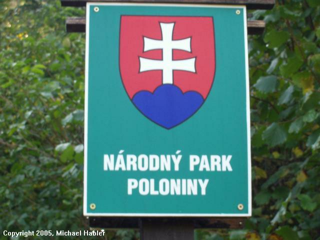
At the beginning of the road to Stakcin, there stood a nature park sign noting the protected area "Poloniny" (the objective of my journey), now in the region (it was not established yet in 2001), which is only slightly publicized or recommended to tourists. It is the newest Slovakia national park. But very beautiful! I again drove on after I saw the Ulic signs, and another indicating the "Kostoly Dreveny monument" which refers to the beautiful wooden churches, which are in the small villages (e.g. in Rusky Potok). From Ulic the road only goes north, and it ends approximately 12 km later in Nova Sedlica - the objective of my journey and also the easternmost municipality of the Slovakia. The Slovaks calls the place "the end of the world", because it is at this point that no one can travel further. On the way I passed police in a brand-new Range Rover jeep – the patrols were obvious because of its proximity to the Ukraine - border. As I drove past, I noticed that I was being carefully examined – what brings a German here to this region???
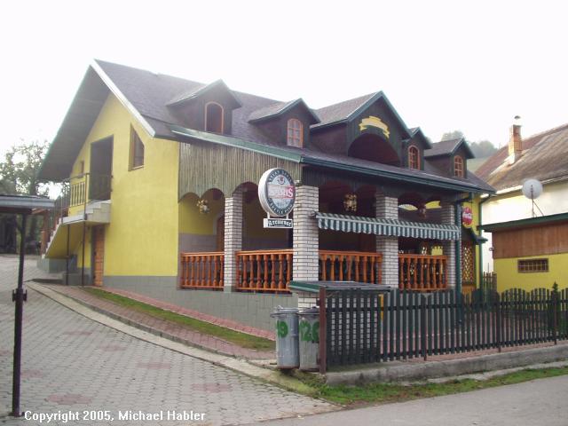 In a short time I arrived at the very beautiful (the only official
one) pension named
Kremenec ( in Nova Sedlica – inexpensive,
nice, recommended!!!) - It is very close to the mountain Kremenec, which I had
planned (still not suspecting) to ascend (hiking) the next day.....
In a short time I arrived at the very beautiful (the only official
one) pension named
Kremenec ( in Nova Sedlica – inexpensive,
nice, recommended!!!) - It is very close to the mountain Kremenec, which I had
planned (still not suspecting) to ascend (hiking) the next day.....
After I arrived at the pension and was greeted to a friendly reception and
included a good dinner, the police officers came in the door, in order to
inquire with the innkeeper about me. After this was discussed, I was examined
again distrustfully by them (after they received a friendly "Dobry more vecer"
from me only stupidly). Then they disappeared again from the reception area - a
rather embarrassing appearance – the greetings from the state servants for a
tourist. Their behavior was reminiscent of old times and old thinking, which I
still remember from GDR - times. Quickly this event was forgotten and after
plenty of Kofola, I retired to my room on the upper floor, in order to sleep.
The following day I arose at 7 o'clock to climb the three-peak mountain, since I wanted to experience my long cherished dream to get to the peak KREMENEC. I traveled 1 km by car above the tourist information center to park, where there is also the Poloniny - national park administration building. Unfortunately it is closed Sundays, and it was not possible for me to buy a detailed hiking map (I made several attempts in department stores in the country before without success - even after several days in the country I did not find ANYWHERE the referenced VKU map – here is some room for improvement.)
 I nevertheless gained some information from other visiting tourists and now
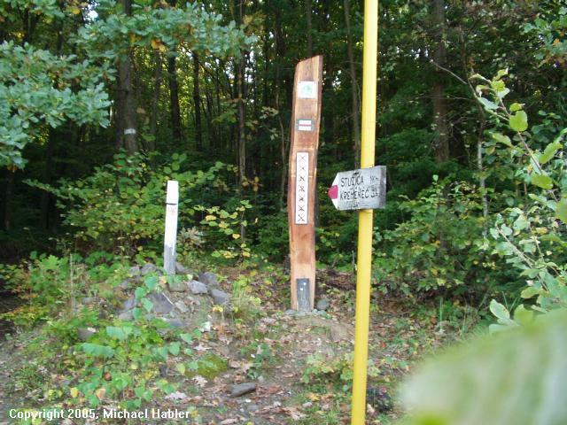
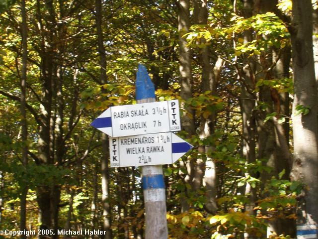
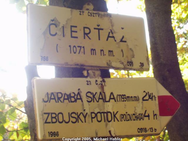
enthusiastically began the mountain ascent. The signs starting from Nova Sedlica
indicate this trip is 3 hours one-way. First it goes up a narrow ridge, but it
is a very accessible forest route. One quickly breaks into a sweat, however the
wonderful air and Fauna and Flora in each case compensates. After approximately
45 minutes I arrived at a fork, where the sign directs you to the left towards
the Kremenec, indicating a hiking time of 3h!! Something cannot be right here?!
Later it became clear to me that there were probably not enough signposts/guides
and a duplicate sign from the valley was posted there.
I nevertheless gained some information from other visiting tourists and now
enthusiastically began the mountain ascent. The signs starting from Nova Sedlica
indicate this trip is 3 hours one-way. First it goes up a narrow ridge, but it
is a very accessible forest route. One quickly breaks into a sweat, however the
wonderful air and Fauna and Flora in each case compensates. After approximately
45 minutes I arrived at a fork, where the sign directs you to the left towards
the Kremenec, indicating a hiking time of 3h!! Something cannot be right here?!
Later it became clear to me that there were probably not enough signposts/guides
and a duplicate sign from the valley was posted there.
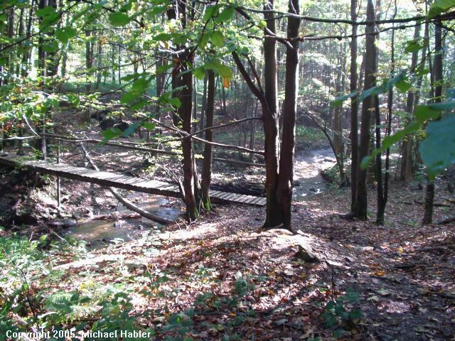
![]() To my surprise the way ascended now as a mud path, …The way became ever more
difficult, the upward gradient does not seem right - oh oh, this was not what I
expected. From such ways anywhere the speech was not.... after only 20 steps I
stopped and saw the verschnaufen mentioned in the hiking books I read, although
I am not the Untrainierteste.... Finally I saw the upward slope and after that a
curve came - and what was beyond it? Another upward slope!!! That was already a
thing for itself, afterwards must I now still schmunzeln... Before the hike, I
had packed myself a 2L - bottle of mineral water, since it was not too much and
I didn’t want too much unnecessary ballast, but I finished the d bottle and at
the brook I filled it again and then drank it all down!!!
To my surprise the way ascended now as a mud path, …The way became ever more
difficult, the upward gradient does not seem right - oh oh, this was not what I
expected. From such ways anywhere the speech was not.... after only 20 steps I
stopped and saw the verschnaufen mentioned in the hiking books I read, although
I am not the Untrainierteste.... Finally I saw the upward slope and after that a
curve came - and what was beyond it? Another upward slope!!! That was already a
thing for itself, afterwards must I now still schmunzeln... Before the hike, I
had packed myself a 2L - bottle of mineral water, since it was not too much and
I didn’t want too much unnecessary ballast, but I finished the d bottle and at
the brook I filled it again and then drank it all down!!!
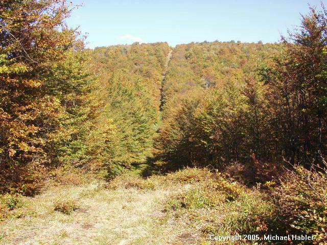
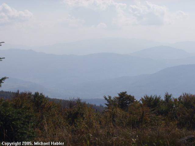
The sun shone through the trees - I was on top! However I was still not on
the mountain summit, but approximately at half way. This place is called
"Stuzica" - a beech forest in the coniferous forest, absolutely natural and
uninterrupted. One can enjoy absolute silence there, without hearing a human
sound - a wonderful experience. Where else is it so still? Before me lay
majestic mountain chain, which forms the Ukraine and Poland border convergence -
the small problem is that between myself and the border lies another deep valley
- the valley of the river Stuzica.... Thus I followed the
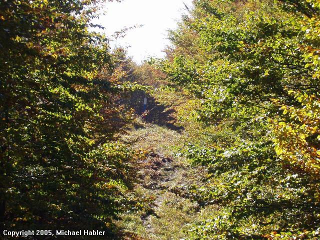 narrow way down to
reach the river Stuzica. This was 1 km, before it flows into the Ukraine.
Somehow this has already been adventurous, if one knows that one is so close to
the former large "Soviet Union" - which was always described to me as so far
away..... In the Stuzica valley I discovered, what unfortunately only later I
learned, that in former times an extensive network of a forest railway (similar
the network of the museum course at Kysucke Nove Mesto). One can discover, and
probably still trace its path – though I didn’t know this at the time.
narrow way down to
reach the river Stuzica. This was 1 km, before it flows into the Ukraine.
Somehow this has already been adventurous, if one knows that one is so close to
the former large "Soviet Union" - which was always described to me as so far
away..... In the Stuzica valley I discovered, what unfortunately only later I
learned, that in former times an extensive network of a forest railway (similar
the network of the museum course at Kysucke Nove Mesto). One can discover, and
probably still trace its path – though I didn’t know this at the time.
 The adjacent Ukrainian national territory is part an area called the "Podkarpaty"
and was for a long time a possession CSSR, and on Ukrainian side also a village
called "Stuzycja" and the people speak the same Rusyns as the older people in
the Slovakian border area. Now I had to climb to the other side of the valley
again steeply uphill, the terrain resembled to a large extent as I previously
described. However it was still narrower and one jumped often only from stone to
stone. No hikers were to be seen far and wide. I wondered what happens, if one
here is hurt or has other problems.... However, my mind was eased by knowing
that starting from a certain height on the ridge, the "Eurotel SK" was found on
Handynetz..... After some time in the forest it opened suddenly stood on the
mountain side, directly before me a Ukrainian blue - yellow marked border stake.
FINALLY AT THE TOP!!! But not completely, but it was not far to go,
The adjacent Ukrainian national territory is part an area called the "Podkarpaty"
and was for a long time a possession CSSR, and on Ukrainian side also a village
called "Stuzycja" and the people speak the same Rusyns as the older people in
the Slovakian border area. Now I had to climb to the other side of the valley
again steeply uphill, the terrain resembled to a large extent as I previously
described. However it was still narrower and one jumped often only from stone to
stone. No hikers were to be seen far and wide. I wondered what happens, if one
here is hurt or has other problems.... However, my mind was eased by knowing
that starting from a certain height on the ridge, the "Eurotel SK" was found on
Handynetz..... After some time in the forest it opened suddenly stood on the
mountain side, directly before me a Ukrainian blue - yellow marked border stake.
FINALLY AT THE TOP!!! But not completely, but it was not far to go,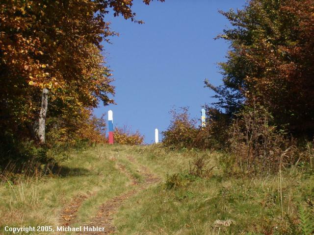 to the left
one had still had a final steep climb to pinnacle, where three heights of land
come together, at 1221m height. When I arrived at the top, at the same time two
other hikers from Poland came up and we welcomed each other immediately and
cordially - the first humans in 3 and ½ hours!!
to the left
one had still had a final steep climb to pinnacle, where three heights of land
come together, at 1221m height. When I arrived at the top, at the same time two
other hikers from Poland came up and we welcomed each other immediately and
cordially - the first humans in 3 and ½ hours!!
I did not see the Ukrainian border soldiers other reports talked about anywhere, They obviously don’t have problems with illegal immigrants at these heights as I was told about. They prefer the more the lonely valleys with good escape routes in the lands.... However unregulated, it is always recommended that you carry your passport on such hikes in the Grenzgeiet.
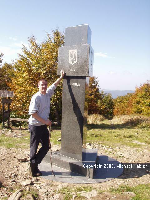
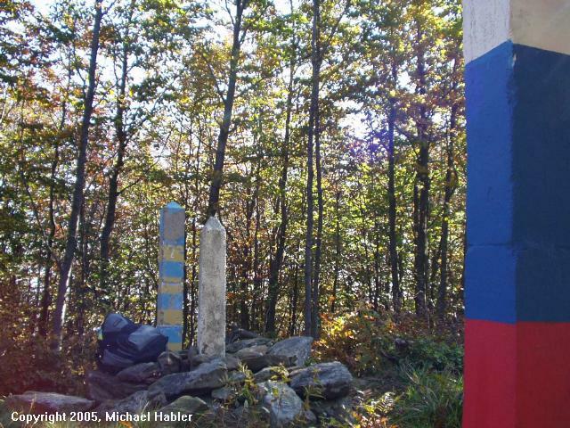
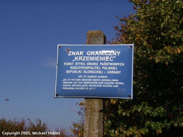 On the mountain in the year 2001 a large triangular stone monument was
erected, in which the name of the place is engraved in each national language
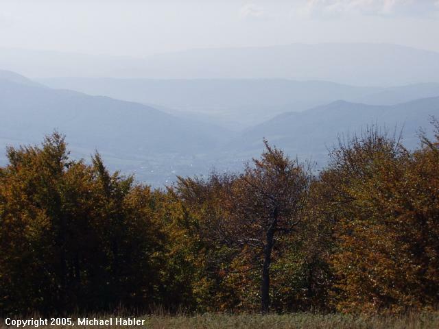
respectively. There we photographed each other in perfect weather and blue sky –
while past pictures (nearly NOTHING found, only rare) from the Internet, people
in the mountain always shows fog or overcast – I had enormous luck! One could
look in the distance and see the Polish tourist area "Bieszcady", or look far
towards the Ukraine and also see the village Nova Sedlica, picturesquely far
away. This was a wonderful feeling to finally arrive and stand there absolutely
at this very spectacular height, after the difficulty of ascent, but for me the
fulfillment of a dream and to see the special easternmost geographic point in
the SK and three-nation-convergence point of Poland/Slovakia/Ukraine.
On the mountain in the year 2001 a large triangular stone monument was
erected, in which the name of the place is engraved in each national language
respectively. There we photographed each other in perfect weather and blue sky –
while past pictures (nearly NOTHING found, only rare) from the Internet, people
in the mountain always shows fog or overcast – I had enormous luck! One could
look in the distance and see the Polish tourist area "Bieszcady", or look far
towards the Ukraine and also see the village Nova Sedlica, picturesquely far
away. This was a wonderful feeling to finally arrive and stand there absolutely
at this very spectacular height, after the difficulty of ascent, but for me the
fulfillment of a dream and to see the special easternmost geographic point in
the SK and three-nation-convergence point of Poland/Slovakia/Ukraine.
The young hikers identified themselves as Czech citizens, who after 2 days in
the mountains hiking had come from the well-known Polish mountain "Wielka Rawka"
- now I could communicate finally again and understand some of what, was spoken
to me - Tschecho - Slowakisch in this region hardly ever succeeded (East
Slovakia language has a very strongly dialect, even those from Western Slovakia
have trouble understanding it.) Fortunately they both also spoke German and thus
decided that together we would descend
 towards Nova
Sedlica. During the descent we spoke
of many topics, how the relationship from CZs to SKs etc., the political and
economic situation in Slovakia from a respectable Czech view - it was
interesting, to hear from somewhat from young impartial people (both are
teachers in Brno) - I noted some experiences and observations of the Czech
Republic and of Slovakia, which I had made and it was amazing how similar our
opinions were!
towards Nova
Sedlica. During the descent we spoke
of many topics, how the relationship from CZs to SKs etc., the political and
economic situation in Slovakia from a respectable Czech view - it was
interesting, to hear from somewhat from young impartial people (both are
teachers in Brno) - I noted some experiences and observations of the Czech
Republic and of Slovakia, which I had made and it was amazing how similar our
opinions were!
 Unfortunately my fears were partly confirmed that there is still too many old
bureaucrats both in CZ and in SK, which still obstructs a real "union" in the
sense of the European Union. Also this often prevents self initiatives by the
inhabitants, in order to better set tourism in motion!
Unfortunately my fears were partly confirmed that there is still too many old
bureaucrats both in CZ and in SK, which still obstructs a real "union" in the
sense of the European Union. Also this often prevents self initiatives by the
inhabitants, in order to better set tourism in motion!
And it is not just the almighty God called money, often is it small things, that prevent so much... hopefully in the future the European Union - responsible persons here also soon more exactly, in order to eliminate bad government, how they often do it in Germany (with partial senseless demands.)
 .... After
approximately 6.5 h I, after the steep descent over another distance with my
feet hurting badly, I arrived again at Nova Sedlica and reached my car with
almost my last strength. The national park administration was opened now
.... After
approximately 6.5 h I, after the steep descent over another distance with my
feet hurting badly, I arrived again at Nova Sedlica and reached my car with
almost my last strength. The national park administration was opened now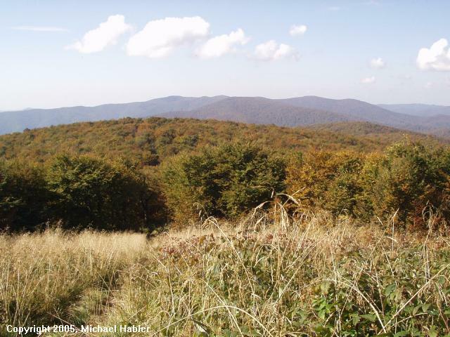 but I
still didn’t find the desired hiking map - unfortunately right in the middle of
the region it still could not be found!! In compensation there were however
different booklets and picture volumes, most of them published in 1986 -, but
nevertheless interesting! The dam Starina, which I addressed a while ago, was
however not yet included in the pictures, - an interesting sight! Now off to the
pension, where I (cold) showered and then went to the terrace of the restaurant,
where the CZ hikers were already waiting.
but I
still didn’t find the desired hiking map - unfortunately right in the middle of
the region it still could not be found!! In compensation there were however
different booklets and picture volumes, most of them published in 1986 -, but
nevertheless interesting! The dam Starina, which I addressed a while ago, was
however not yet included in the pictures, - an interesting sight! Now off to the
pension, where I (cold) showered and then went to the terrace of the restaurant,
where the CZ hikers were already waiting.

Editor's note: The hiking map Michael was seeking is the VKU Tourist Map HM163 (formerly 118) - Bieszczady, Bukovské vrchy.
Links to off-site webs will open in a new window. Please disable your pop-up stopper.
Last Update: 15 November 2020 Copyright © 2003-2021, Bill Tarkulich